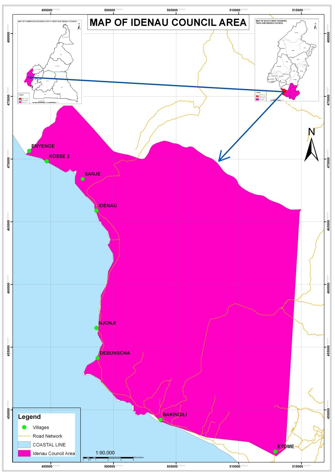
The Idenau council (within West Coast Subdivision) was created by presidential decree No 95/206 of 24th April 1995. Idenau is the head quarters of the West Coast Sub division located in Fako Division of the South West Region of Cameroon. It is located some 29km from Limbe city. The Idenau municipality has a total surface area of 16km2 with an estimated population of 30,000 inhabitants living in 8 villages, among which are fishing ports, native communities and CDC camps (Council project report 2010). Field survey reveals that the actual population is 8139 persons. It is located between latitude 4.2333330N and longitude 8.98333330E with an altitude of about 300m above sea level (asl) in the mainland area and 5m in the maritime area. Generally, Idenau municipality is found on the North of Atlantic Ocean and the windward side of Mount Cameroon.
It is bounded to the North by a stretch of the Mount Cameroon National Park, to the North East by Buea sub-division, to the East by Limbe II municipality, to the South by the Atlantic Ocean, to the West by Bamusso sub-division, and to the North West by Mbonge Sub-division. The average temperature range is about 25-300C and have a mean monthly rainfall of about 5000mm to 8000mm.
Climate
Idenau council area has an equatorial climate that is marked by two distinct seasons (dry and rainy season). Rainfall is unimodal and spreads from March to November with a temperature range of about 25-28˚C. The rainfall rises up to 4000 mma-1 with its peak being in July, August and September. The peak of the dry season falls in December and January.
Average annual temperature is 27°C and the wind speed is 2 mph. The mean annual relative humidity ranges between 80% and 95% (CDC weather records). These climatic conditions make the soil favourable for the growth of oil palms, cocoa, cassava and other food crops. The West coast is a distinct area with respect to rainfall pattern. Debundscha is noted to have the highest rainfall in Africa, and rainfall is observed throughout the year.
The dry season is characterized by dry winds that blow from the mountain in a North East to a South Westerly direction. During this period, daily temperatures are high with a slight drop in the night. During the rainy season rains are heavy creating a favourable environment for rain-fed cultivation. The rains are occasionally associated with storms and floods that are destructive to crops and property.
Soils
The dominant soil type in this municipality is the dark fertile and stony volcanic soils with patches of alluvial and sandy loam soils (MINADER report). The hills are a dissected plateau of old volcanic rocks with a few up-faulted sedimentary belts. These soil types coupled with the level terrain is very good for agriculture generally and plantation agriculture in particular.
Relief
The relief of the council area is a flat surface with gentle slopes and patches of steep slopes towards the mountain. This level nature of the area greatly accounts for the choice of the location of the Cameroon Development Cooperation (CDC) plantations on the mainland areas. There are swamps, creeks and sand-pits at the coastal region close to the Atlantic Ocean.
Hydrology
Besides Atlantic Ocean, the main land area of the council is endowed with so many water courses including rivers, creeks, streams, and springs. Some of these water courses include; Ndiweh spring of Etome and “cold source” of Bakingili which serve as the main source of can water and the point of construction of community catchment. Some of these water courses, empty into the sea.