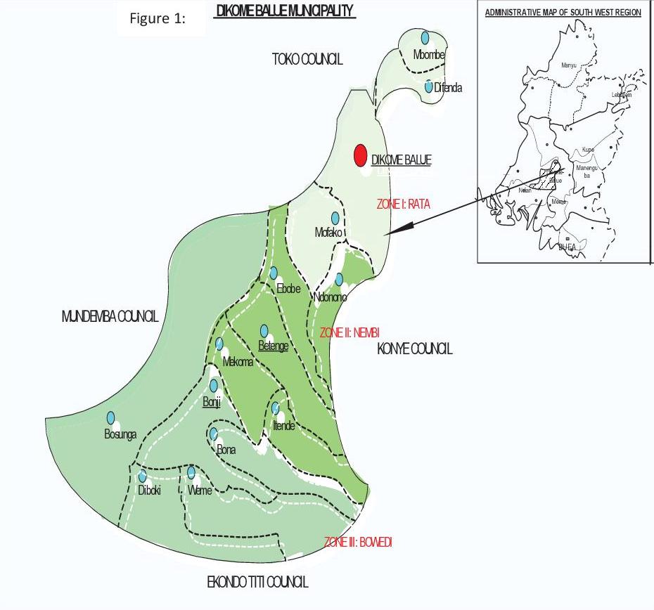
The council (Dikome Balue municipality map) below is located in the South West Region of Cameroon, in Ndian Division, in Dikome Balue Subdivision. It is limited in the West by Mundemba council, in the South by Ekondo titi Council, in the East by Konye council, in the North by Tiko council. Its GPS points are: X = 04.90148; Y = 009.25526; Z = 1168. It situated at 107 km from Douala and 36 km from Kumba. It covers 5000 km2, that is 1,33% of the national territory. It is made of 14 villages; 1 urban space (Dikome Balue) with 7 quarters, 3 development zones: Rata,Bowedi and Nembi
- Agriculture
- Livestock
- Fishing
- Hunting/Apiculture
- Exploitation of minerals
- Commerce
- Handicraft
CLIMATE
The climate is mostly cloudy and rainy, observed temperatures varie between 18 to 24 0C. the humidy is about 90%, Rainfall ranges from 2000 to 3000 mm. Two seasons are also observed within the municipality. The longest one being the rainy season; from mid March to mid November while the dry season goes from mid November to mid March. But rain falls in Dikome Balue throughout the year. the biggest rainy period being from July to September
SOILS
It is a volcanic fertile soil rich of humus on the top soil covering the 14 villages. The subsoil being brown while the topsoil is black. it is mixed with stones of micro, medium and big sizes.it is made of Clay,sandy and silt. The land is used (Figure 2:. Soil occupation) here for settlement, building of infrastructures, agriculture, livestock and fishing activities, , forest activities (hunting, forest exploitation, honey collection, mushroom collection, non timber forest product collection)
RELIEFS
It is diversified. It is shared in between chains of hills and depressions covering the 14 villages. The tallest hills are found at Dikome and Mofako being Rumpi highlands and RATA mountain with composite volcano of the Cambrian type that has not erupted in our recent times. These mountains range connect with the Manenguba, kupe, Fako and Equatorial Guinea highlands. Beside them, are also very tall rocks at Itende, Bonji and Difenda.
HYDROGRAPHY
Hydrography network (figure 3: Hydrography) is composed of surface and underground water. Surface water is made of abundant springs found everywhere in each of the 14 villages. They take their source from the hills, flow down to lower area and meet to form 49 streams which also merge to form 9 rivers in the municipality and 5 streams respectively called Mokorikori, Mofombi, Nya, Bosame, and Bifake are found at Dikome, Meme river found at Ebobe, Betenge and Mekoma, Yoke river found at Diboki and Weme, IYAKO river found at Bosunga (hammock bridge); Kombone river found at Mbombe. 16 waterfalls are also found.Underground water is found everywhere with a depth of not less than 1,5 m.
VEGETATION
It is made of montane and submontane virgin forest, of agriculture food and cash crops (cocoa, coffee, palms, cassava, yams, plantains..) covering each of the 14 villages. Planted eucalyptus are found in Dikome Balue. Identified tree species are: Chlorophora excelsa (Iroko), Pterocarpus soyauxii (padouk); Terminalia superb Engl.& Diels (Frake); Entandrophragma cylindricum Sprague (Sapelli),Piptadeniastrum africanum (Dabema), Lophira alata (Azobe),Distemonanthus benthamianus baill (Movingui), Baillonella toxisperma (Moabi), Nauclea diderrichii (Bilinga) found in the 14 villages,the greater stock is found at Dikome Balue Mbombe and Bosunga. There are also planted species like Eucalyptus at Dikome. Identified abundant and various medicinal plants include: Cola nitida (cola),Prunus africana (Prunus), Cantharelus spp (Mushrooms); Carica papaya (Pawpaw),Khaya anthoteca (mohagany).Non timber species: Raphia spp, Laccosperma spp (Rattan), All are found in the 14 villages but Dikome Balue, Bosunga, mbombe have the greatest quantity