Akwaya has the potentials of agricultural activities as well as mining. The many rivers could be a source of high fishing activity, and a source for developing fishing ponds in the area. There is the Takmon Cooperative Society.
Akwaya Sub-Division is in Manyu Division of the South West Region of Cameroon. This Sub-Division was created in 1963. The Sub-Division has five Court Areas viz. Takamanda, Boki, Mbulo, Assumbo and Mesaga-Ekol
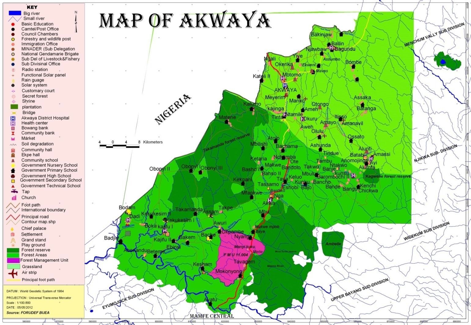
Akwaya Council was created in 1966. The Council and Sub-Divisional head quarters are located about eighty five (85) miles from Mamfe. It is a border area with Nigeria. So far, access to Akwaya is by foot from Mamfe and by vehicle, through Nigeria. The road is impassable in the rainy season. Akwaya Council area is bounded to the North-West by, Momo and Menchum Divisions to the East by the Eyumojock Sub-Division and to the South by Mamfe Central Sub-Division and West by Upper Bayang Sub-Division. Akwaya council area has 99 (102 seen on the ground) gazetted villages. It has a total surface area of 488km2.
Climate
The rainfall is heavy and begins in April sparingly and intermittently, with heavy downpours in July and August. During this period, the weather is cool, rivers are flooded and travelling is very difficult and impossible in some areas. Rainfall is up to 4500mm per year in this region. The mean annual temperature in this area is 270C1. The dry season stretches out from late November to early June. This pattern may however not be respected owing to the phenomenon of climate change. Usually all the rivers flood during the months of July, August, September and October. The temperature for most of the time is humid. There is harmattan in the months of December – February, more severe in the northern part than in the south. During this period there is much wind
Hydrology
The entire Akwaya Council area is blessed with many rivers, streams, and springs. Some of the main rivers include: Cross river, Ebinsi River, Tachene River, Mamfi River, Eveh River, Mone River, Tafu river, Makumonou River, just to mention a few. Most of the rivers empty themselves into the cross river down to Nigeria and then into the sea. Akwaya shares the cross river with Eyumojock and Mamfe Central Sub-Divisions. The inhabitants use the streams and springs for drinking. The rivers are used for fishing and trade channels into Nigeria in parts of the north – mesaga-ekol and Boki court area in the south.