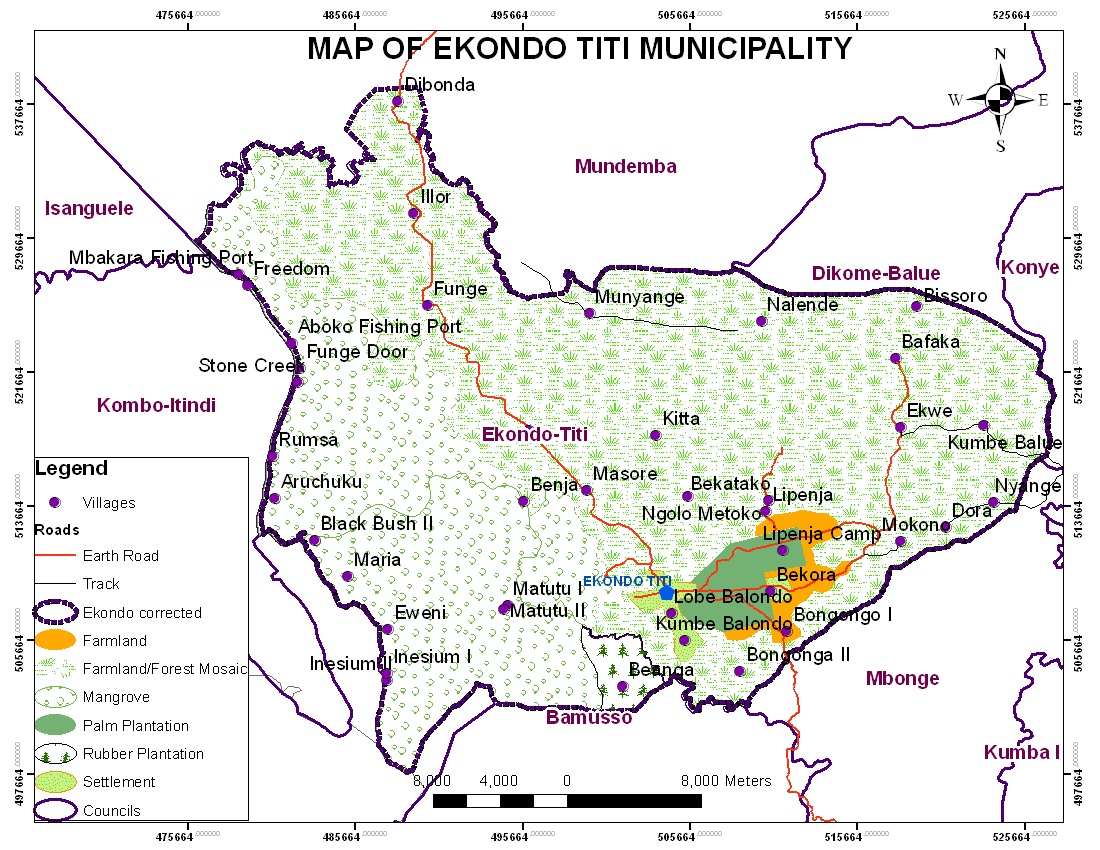
Created in 1977 by Presidential decree No.77/205 of 29/06/1977, splitting the then Ndian area council into four new councils; Ekondo-Titi, Mundemba, Bamusso and Isangele. The Ekondo-Titi council has a population of about 56,503 inhabitants on 1.750 square kilometres surface area.
The sub-division is made up of the maritime and the main land area. The main land area is composed of 26 villages (Dibonda, Loe, Illor, Funge, Ekondo-Nene, Masore, Kitta, Nalende, Munyenge, Bisoro, Bafaka, Pondo, Kotto, Kumbe Balue, Ekwe, Njima, Iribanyange, Dora, Mokono, Bekatako, Lipenja, Bongongo I, Bongongo II, Lobe Town, Kumbe Balondo and Berenge), 1 C.D.C workers camp(Beyanga) and 3 urban spaces(Ekondo-Titi, Bekora and Lobe Estate), while the maritime constitutes the 19 kombos (Eweni, Aruchuku, Aboko, Funge Door mouth, Bakara, Benja, Stone creek, Godgift, Freedom, German Beach, Nyanga, Matutu I, Matutu II, Inesium I, Inesium II, Black Bush I, Black Bush III, Kombo Maria, Rumsa,).
The council is located some 56km from Kumba the economic headquarters of the South West region, the Ekondo-Titi council is bounded to the East and South East by the Mbonge Council, North East by Dikome Balue Council, North West by Mundemba Council, West by Kombo Itindi Council and South by Bamusso Council.
The council has huge forest resources, a very rich mangrove swamp forest, a maritime zone and a huge agro-industrial palm plantation.
Climate
Ekondo-Titi, as well as the entire Ndian Division has an equatorial climate, but its dominant lowland topography (exempting the highlands towards the north east), and its proximity towards the sea provokes an equatorial maritime climate type along the Atlantic coast. The Climate is characterised by two seasons (rainy and dry) determine by the apparent movement of the overhead sun and seasonal tropical winds.
Generally, annual rainfall is high. It ranges from 480mm on the lowlands and 4000mm on the windward slope of the Rumpi Hills. Maximum rainfall occurs between July and October when the South West Monsoon winds or the Westerly’s are strongest and minimum between December and January when the North east trade winds or hamattan are dominant. Temperatures are uniformly high, mean annual being about 26˚C; it reduces by altitude to 16 or 20˚C towards the villages to the Rumpi Hills.
Requisite climatic conditions and relief gives the sub-division from the Atlantic coast, a mangrove swamp forest, an equatorial evergreen forest up to the foot of the Rumpi Hills and an Afro-Montana forest on the Rumpi hills where patches of Savannah also exist.
Vegetation
The vegetation is quite rich in biodiversity with tropical species of economic importance including hard wood like Iroko, sapelle, mahogany, small leaves, mangrove etc, and a variety of NTFPs and Fauna. However, this forest and biodiversity is alarmingly degrading by small holders and agro-industries like PAMOL and CDC, unsustainable illegal logging, subsistence and cash crop agriculture and poaching for bush meat.
Fauna and Floral
The Ekondo-Titi municipality is endowed with a forest composed of a rich variety of fauna and floral. It also possesses a mangrove forest and creek which are breeding sites and habitat of diverse fish and other aquatic species. Domestic animals (Cattle, cat, dog goat, sheep, fowls, pig) and fruit trees (mango, pear, plum, guava, orange, grape, apple etc) are common in the villages.
Soils
The distribution of soil types in the Ekondo-Titi area is related to the local vegetation, relief and climate. There are basically three distinct soil types in the region, dark brown alluvial soil (Bekora upto Bisoro), Lateralitic soil (Masore upto Dibonda), silty alluvium (Kumbe Balondo, part of Lobe Town and the maritime villages) which is subject to seasonal flooding especially in the lowland villages. The hilly area is a dissected plateau of old volcanic rocks with a lot of folded sedimentary belts. This soil type is very good for plantation agriculture especially palms and cocoa.
Relief
The Ekondo Titi municipality stands out as an area of gentle relief with generally lowlands in the south, west, north and north west (Balondo and maritime villages). As you move towards the east and North-East, the relief changes to hilly landscape which composes of a chain of folds resulting from denudational forces. Some areas in the East have altitude of upto 1000m above sea level. Close to the Atlantic Ocean are the mangrove swamps, several creeks, and sand-spits that stretch from the muddy coast lines of Ekondo Titi to the Ndian River Basin.
Hydrology
The Ekondo Titi council is blessed with quite a number of water courses including rivers, streams and spring. The main rivers include rivers Meme and Ma’a which both take their rise from the Rumpi Hills and empty into the Atlantic Ocean and River Ndian respectively.